6.4 The Impacts of Earthquakes
Some of the common impacts of earthquakes include structural damage to buildings, fires, damage to bridges and highways, slope failures, liquefaction and tsunami. The types of impacts will depend to a large degree on the type of area where the earthquake is located: whether it is predominantly urban or rural, densely or sparsely populated, highly developed or under-developed, and of course on the ability of the infrastructure to withstand shaking.
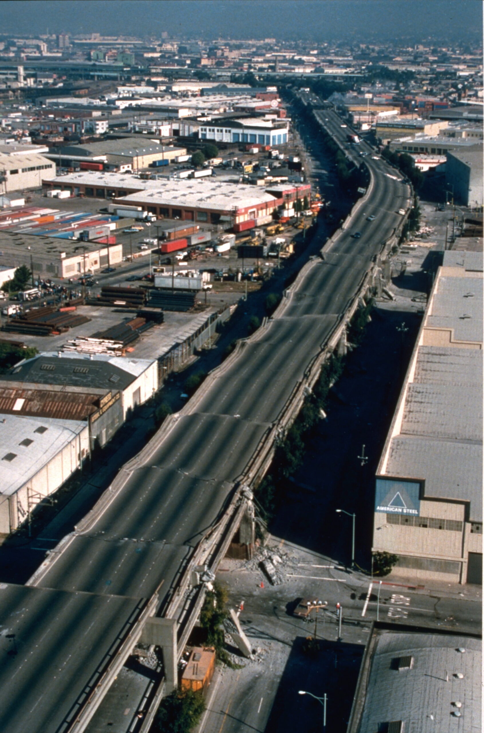
As we’ve seen from the example of the 1985 Mexico earthquake, the geological foundations on which structures are built can have a significant impact on earthquake shaking. When an earthquake happens the seismic waves produced have a wide range of frequencies. The energy of the higher frequency waves tends to be absorbed by the solid rock of the crust, while the lower frequency waves (with periods slower than 1 second) pass through the solid rock without being absorbed, but are eventually absorbed by soft sediments. In many cases the soft sediments amplify the seismic shaking, so it is very common to see much worse earthquake damage in areas underlain by soft sediments than in areas of solid rock. A good example of this is in the Oakland area near to San Francisco, where parts of a two layer highway built on soft sediments collapsed during the 1989 Loma Prieta earthquake (Figure 6.4.1).
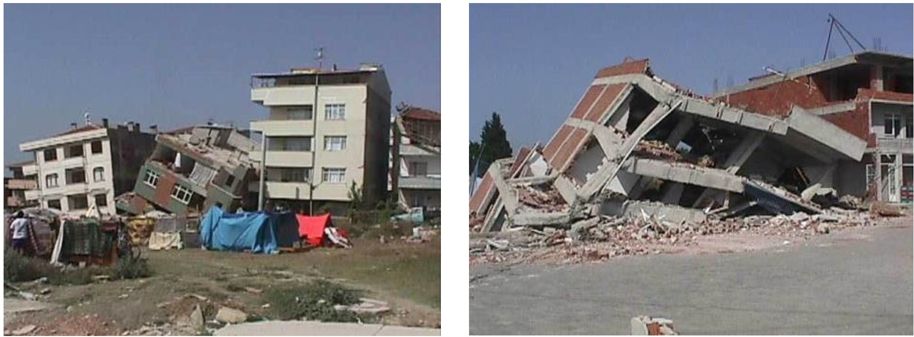
Building damage is also worse in areas of soft sediments, and multi-story buildings tend to be more seriously damaged than smaller ones. Buildings can be designed to withstand most earthquakes, and this practice is increasingly applied in earthquake-prone regions. Turkey is one such region, and even though Turkey had a relatively strong building code in the 1990s, adherence to the code was weak, as builders did whatever they could to save costs, including using inappropriate materials in concrete and reducing the amount of steel reinforcing. The result was that there were over 17,000 deaths in the M7.6 1999 Izmit earthquake (Figure 6.4.2). After two devastating earthquakes in 1999 Turkish authorities strengthened the building code, but the new code has only been applied in a few regions, and enforcement of the code is still weak, as revealed by the amount of damage from a M7.1 earthquake in eastern Turkey in 2011.
Some of the common impacts of earthquakes include structural damage to buildings, fires, damage to bridges and highways, slope failures, liquefaction and tsunami. The types of impacts will depend to a large degree on the type of area
where the earthquake is located: whether it is predominantly urban or rural, densely or sparsely populated, highly developed or under-developed, underlain by weak sediments or strong hard rock, and of course on the ability of the infrastructure to withstand shaking.
Fires are commonly associated with earthquakes because gas pipelines get ruptured and electrical lines get damaged when the ground shakes (Figure 6.4.3). Most of the damage in the great 1906 San Francisco earthquake was caused by massive fires in the downtown area of the city (Figure 6.4.4). Some 25,000 buildings were destroyed by those fires, which were fueled by broken gas pipes. Fighting the fires was difficult because water mains were also ruptured. The risk of fires can be reduced through P-wave early warning systems if utility operators can reduce pipeline pressure and close electrical circuits.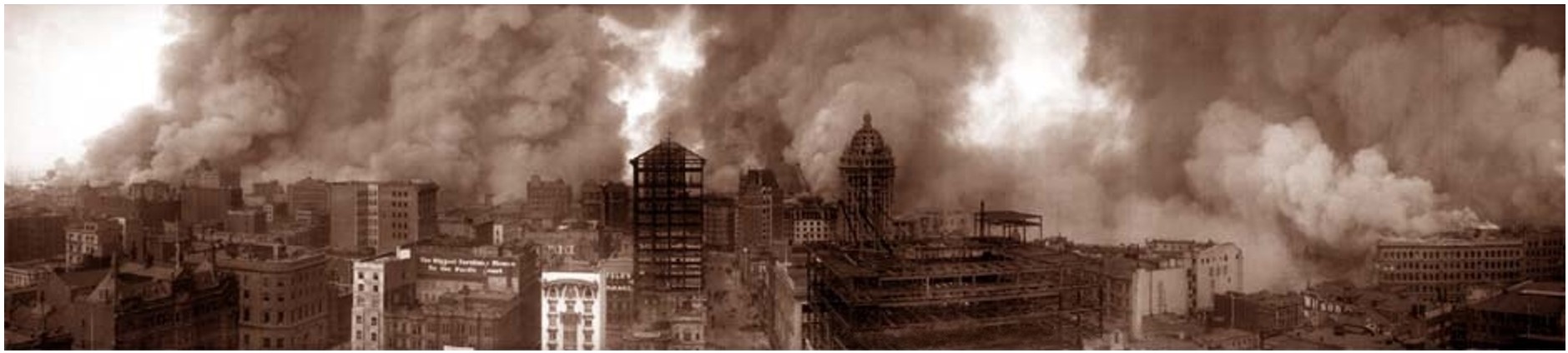
Figure 6.4.4 Fires in San Francisco During the 1906 Earthquake
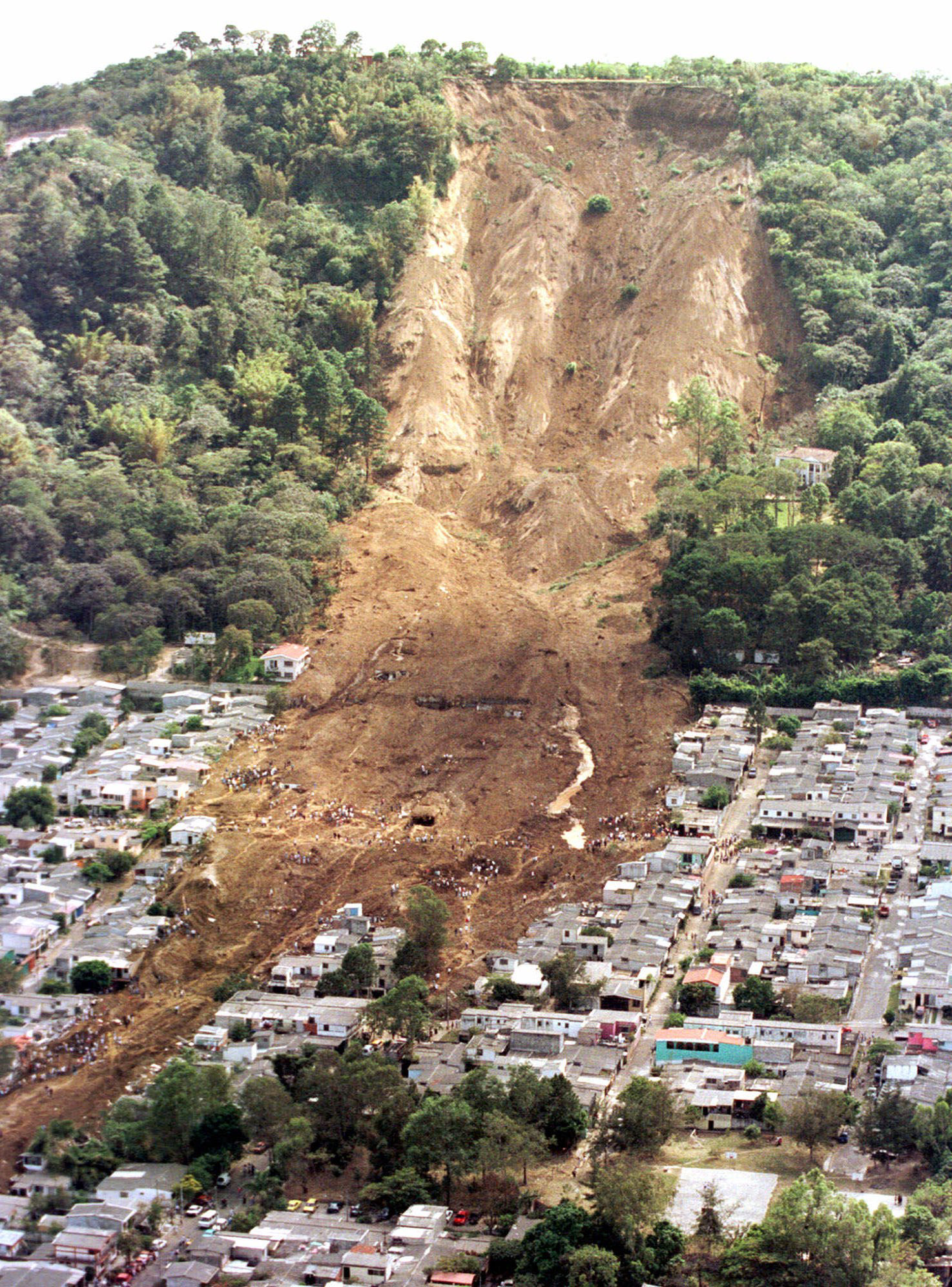
Earthquakes are important triggers for failures on slopes that are already prone to weakness. An example is the Las Colinas slide in the city of Santa Tecla, El Salvador, which was triggered by a M7.6 offshore earthquake in January 2001 (Figure 6.4.5).
Another example is from the 2018 Sapporo earthquake in Japan which caused thousands of debris flows in an area that had recently been soaked by summer rains and then a typhoon (see Figure 5.1.7 in Chapter 5).
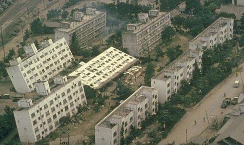
Ground shaking during an earthquake can be enough to weaken rock and unconsolidated materials to the point of failure, but in many cases the shaking also contributes to a process known as liquefaction, in which an otherwise solid body of sediment gets transformed into a liquid mass that can flow. When water-saturated sediments are shaken the grains become rearranged to the point where they are no longer supporting one-another. Instead, the water between the grains is holding them apart and the material can flow. Liquefaction can lead to the collapse of buildings and other structures that might be otherwise undamaged. A good example is the collapse of apartment buildings during the 1964 Niigata earthquake (M7.6) in Japan (Figure 6.4.6). Liquefaction can also contribute to slope failures and to fountains of sandy mud (sand “volcanoes”) in areas where there is loose saturated sand beneath a layer of more cohesive clay.
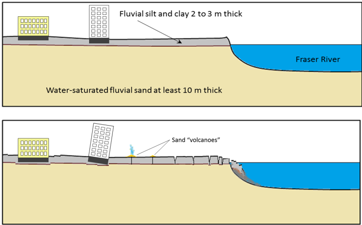
Parts of the Fraser River delta near to Vancouver BC are prone to liquefaction-related damage because the region is characterized by a 2 to 3 m thick layer of fluvial silt and clay over top of at least 10 m of water-saturated fluvial sand (Figure 6.4.7). Under these conditions it can be expected that seismic shaking will be amplified and also that the sandy sediments will be liquefied. This could lead to subsidence of buildings to tilting in areas where liquefaction is inconsistent, and to failure and sliding of the silt and clay layer. Current building-code regulations in the Fraser Delta area require that measure be taken to strengthen the ground underneath before construction of multi-story buildings.
Exercise 6.4 Creating Liquefaction and Discovering the Harmonic Frequency
There are a few ways that you can demonstrate the process of liquefaction for yourself. The simplest is to go to a sandy beach (lake, ocean or river) and find a place near to the water’s edge where the sand is wet. This is best done with your shoes off, so let’s hope it’s not too cold! While standing in one place on a wet part of the beach start moving your feet up and down at a frequency of about once per second. Within a few seconds the previously firm sand will start to lose strength and you’ll gradually sink in up to your ankles.
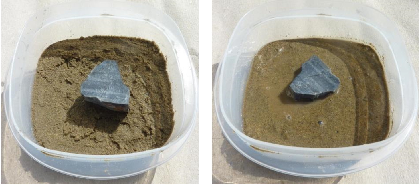
If you can’t get to a beach, or if the weather isn’t cooperating, put some sand (sandbox sand will do) into a small container, saturate it with water, and then pour the excess water off. You can shake it gently to get the water to separate and then pour the excess water away, and you may have to do that more than once. Place a small rock on the surface of the sand; it should sit there for hours without sinking in. Now, holding the container in one hand gently thump the side or the bottom with your other hand, about twice a second. The rock should gradually sink in as the sand around it becomes liquefied (Figure 6.4.8)
As you were moving your feet up and down or thumping the pot, it’s likely that you soon discovered the most effective rate for getting the sand to liquefy, and this would have been close to the natural harmonic frequency for that body of material. Stepping up and down as fast as you can (several times per second) on the wet beach would not have been effective, nor would you have achieved much by stepping once every several seconds. The body of sand vibrates most readily in response to shaking that is close to its natural harmonic frequency, and liquefaction is also most likely to occur at that frequency.
One of the ways to reduce risks to people and property from earthquakes is to understand the types of materials that buildings are situated on in cities. This involves mapping the distribution, thickness and nature of surficial materials such as river sediments, lake sediments, and glacial sediments, and also the degree to which these materials are saturated with water. This type of work has been done in many areas around the world, and an example of such a map is provided on Figure 6.4.9 for the city of Victoria, British Columbia.
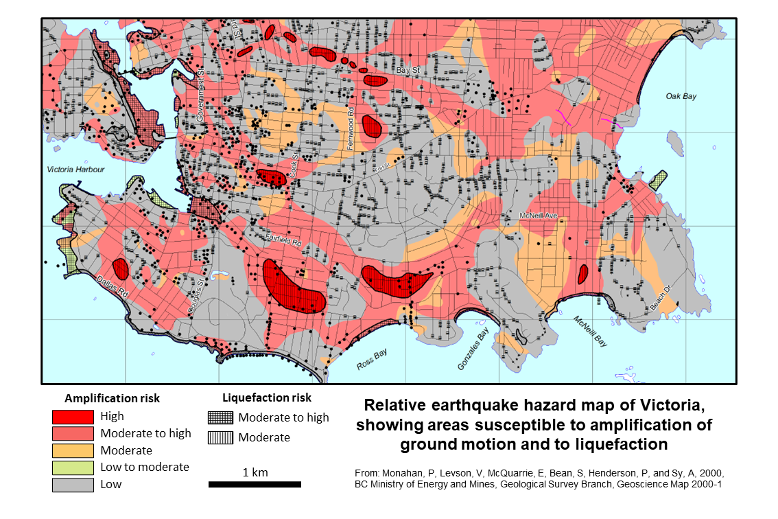
Large parts of Victoria are underlain by bedrock or a very thin layer of sediments on top of bedrock. In other areas there are significant thicknesses of glacial sediments, including till, clay deposited under marine conditions in post-glacial times and post-glacial peat deposits . In several near-shore areas land has been claimed using fill. The earthquake hazard map of Figure 6.4.8 shows lowest amplification risk in bedrock areas (grey), moderate risk in areas of marine clay (orange and pink) and in some areas of near-shore fill (green), and greatest risk in areas where there is peat over top of clay (red).
Liquefaction risk is greatest where the loose sediments are saturated with water, and this applies to some near-shore areas, especially around Victoria Harbour, and in some inland areas where there is peat over clay.
Tsunami
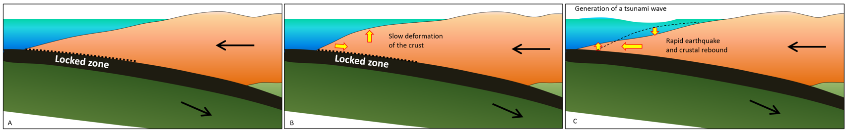
Earthquakes that take place beneath the ocean have the potential to generate tsunami under certain conditions. The most likely situation for a significant tsunami is a large (M7 or greater) subduction-related earthquake. As shown on Figure 6.4.10, during the time between earthquakes the overriding plate gets slowly distorted by elastic deformation; it is squeezed laterally (Figure 6.4.10B) and it is pushed up. When an earthquake happens that deformed crust springs back, resulting in either rapid subsidence of the sea floor, rapid uplift of the seafloor, or both.
Subduction earthquakes with magnitude less than 7 do not typically generate significant tsunami because the amount of vertical displacement of the sea floor is minimal. Sea-floor transform earthquakes, even large ones (M7 to 8), don’t typically generate tsunami either, because the motion is mostly side-to-side, and not vertical. And, of course, earthquakes that take place entirely on land don’t generate tsunami.
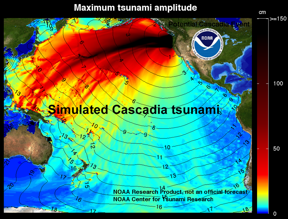
Tsunami waves travel at velocities of several hundred km/h and easily make it to the far side of an ocean in about the same time as a passenger jet. The simulated one shown on Figure 6.4.11, is similar to that created by the January 1700 Cascadia earthquake off the coast of British Columbia, Washington, and Oregon, which was recorded in Japan 9 hours later.
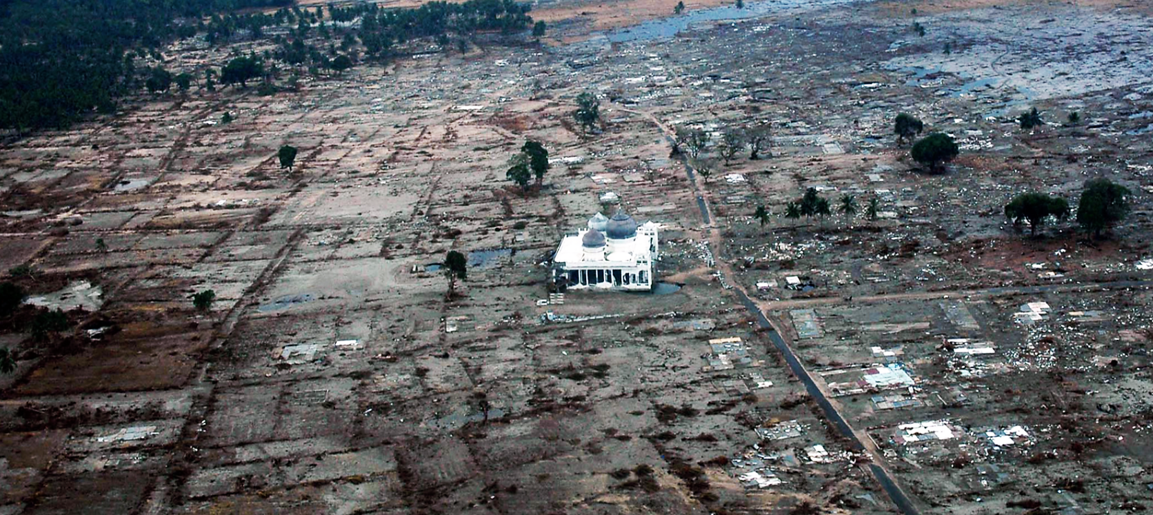
In many earthquake events the damage and loss of life from a tsunami is much greater than those from the earthquake shaking. This certainly applies to the massive (M9.1) 2004 Sumatra earthquake and tsunami, for which the death toll was well over 200,000. An example of the damage from that event is shown of Figure 6.4.12. In fact there is no certainty about the proportion of deaths related to shaking and building collapse versus those from the tsunami because many of the buildings in coastal areas that might have collapsed in the shaking were soon destroyed by the waves.
Approximately 16,000 of the deaths from Japan’s 2011 Tohoku earthquake were a result of drowning or in some other way related to the tsunami , while about 3000 are described as being related to the earthquake . Most of the damage to structures was also caused by the tsunami, including the devastating damage to the Fukushima Daiichi nuclear power station.[1]
Media Attributions
- Figure 6.4.1 Nimitz Freeway by Joe Lewis, 1989, CC BY SA 2.0, via Flickr, https://www.flickr.com/photos/sanbeiji/220646891
- Figure 6.4.2 Collapsed buildings, US Geological Survey public domain image, https://gallery.usgs.gov/media/galleries/1999-izmit-turkey
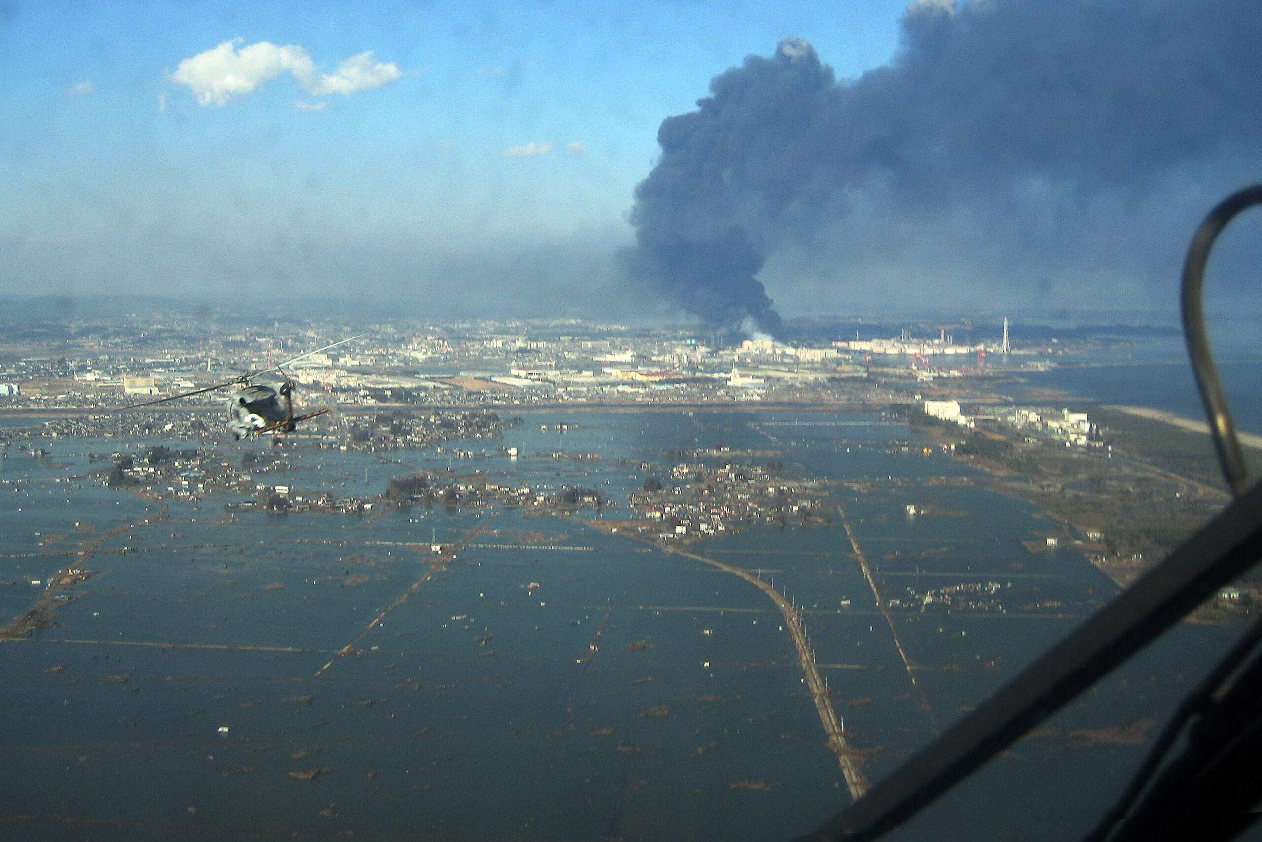
- Figure 6.4.3 Helicopter flying over Sendai, US Navy public Domain image, via Wikimedia Commons, https://commons.wikimedia.org/wiki/File:SH-60B_helicopter_flies_over_Sendai.jpg
- Figure 6.4.4 San Francisco Fire, 1906, public domain image via Wikimedia Commons, https://commons.wikimedia.org/wiki/File:San_francisco_fire_1906.jpg
- Figure 6.4.5 El Salvador Slide, Public domain US Geological Survey image via Wikimedia Commons, https://commons.wikimedia.org/wiki/File:ElSalvadorslide.jpg
- Figure 6.4.6 Liquefaction at Niigata, public domain image via Wikimedia Commons, https://commons.wikimedia.org/wiki/File:Liquefaction_at_Niigata.JPG
- Figure 6.4.7 Steven Earle, CC BY 4.0
- Figure 6.4.8 Photos by Steven Earle, CC BY 4.0
- Figure 6.4.9 Modified by Steven Earle, CC BY 4.0, after Monahan, P., Levson, V., McQuarrie, E., Bean, S., Henderson, P., & Sy, A, (2000). Geoscience Map 2000-1. BC Ministry of Energy and Mines, Geological Survey Branch. https://www2.gov.bc.ca/gov/content/industry/mineral-exploration-mining/british-columbia-geological-survey/publications/geosciencemaps
- Figure 6.4.10 Steven Earle, CC BY 4.0
- Figure 6.4.11 Tsunami from the 1700 Cascadia Earthquake simulated model, Public domain image, NOAA/PMEL/Center for Tsunami Research, http://nctr.pmel.noaa.gov/cascadia_simulated/
- Figure 6.4.12 Tsunami damage to a Community in Aceh, Indonesia, Public domain image, US Navy, https://nara.getarchive.net/media/a-lone-mosque-stands-among-the-damage-of-a-coastal-village-near-aceh-sumatra-86b33f
- International Atomic Energy Agency (IAEA) (2011). Japanese Earthquake Update [Alert Log]. (19 March 2011, 4:30 UTC). https://web.archive.org/web/20110607091828/http://www.iaea.org/press/?p=1463 ↵