5.3 Mitigating the Effects of Mass Wasting
As already noted above, we cannot prevent mass wasting, but in many situations there are actions that we can take to delay it from happening. Where we cannot delay it, there are things we can do to mitigate its damaging effects on people and infrastructure. Where we can neither delay nor mitigate mass wasting, we should have the sense to stay out of the way.
Preventing and Delaying Mass Wasting
It is comforting to think that we can prevent mass wasting by mechanical means, such as the bolts in the road cut at Porteau Cove (Figure 5.2.3), or by draining water out of a slope, as was done at the Downie Slide (Figure 5.2.2), or by building physical barriers. What we have to remember is that the works of man are weak and pathetic things compared to the works of nature. The rock bolts in the road cut at Porteau Cove will start to corrode within a few years, and within a few decades many of them will lose strength. Unless they are replaced—and nobody can guarantee that that will happen—they will no longer be supporting that slope. The drainage holes at the Downie Slide will eventually get plugged up with sediment and chemical precipitates, and, unless they are periodically unplugged (which would be difficult) their effectiveness will be reduced. Eventually, unless new holes are drilled, the drainage will be so compromised that the slide will start to move again.
The important point is that our efforts to “prevent” mass wasting are only as good as our resolve to maintain those preventative measures. We may have created systems to ensure that others will carry out that maintenance in future decades or even future centuries, but there is nothing to ensure that it will be done.
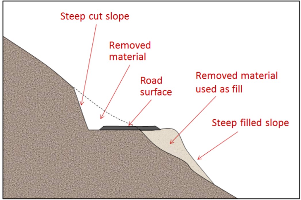
Delaying mass wasting is a worthy endeavour, of course, because during the time that the measures are still effective, they can save lives and damage to property. The other side of the coin is that we must be careful to avoid doing things that could make mass wasting more likely. The most common anthropogenic cause of mass wasting is road construction, and this applies both to remote gravel roads built for resource extraction and to large highways. Road construction is a potential problem for two reasons. First, to create a flat road surface on a slope inevitably involves creating a cut bank that is steeper than the original slope, and might also involve creating a filled bank that is both steeper and weaker than the original slope (Figure 5.3.1). Second, roadways typically cut across natural drainage features, and unless great care is taken to reroute the runoff water, and to prevent it from pooling, oversaturation of materials can result. A specific example of the contribution of construction-related changes to drainage that led to slope instability is the debris flow in North Vancouver that is illustrated on Figure 5.1.5 (above).
Apart from water issues, builders of roads and other infrastructure on bedrock slopes have to be acutely aware of the geology, and especially of any weaknesses in the rock related to bedding, fracturing or foliation. If possible, situations like that at Porteau Cove (Figure 5.2.3) should be avoided—by building somewhere else—rather than trying to stitch the slope back together with rock bolts.
It is commonly believed that construction of buildings on the tops of steep slopes can contribute to the instability of the slope. This may be true, but probably not because of the weight of the building. As you’ll see by completing Exercise 15.3, a typical house isn’t likely to be heavier than the hole in the ground that was made to build it. A more likely contributor to instability of the slope around a building is the effect that it has on drainage.
Exercise 5.3 How Much Does a House Weigh?
It is commonly believed that building a house (or some other building) at the top of a slope will add lots of extra weight to the slope and could contribute to slope failure. But what does a house actually weigh? A standard 1600 ft2 wood-frame house with a basement and a concrete foundation weighs about 145 T (metric tonnes). But most houses are excavated into the ground, and that involves digging a hole and taking some material away, so we need to subtract what that excavated material weighs. Assuming that our 1600 ft2 house required an excavation that was 15 m by 11 m by 1 m deep. That’s 165 m3 of “dirt”, which typically has a density of about 1.6 T per m3.
Calculate the weight of the soil that was removed and compare that with the weight of the house and its foundation.
If you’re thinking that a building a bigger building is going to add more weight, consider that bigger buildings need bigger and deeper excavations, and in many cases the excavations will be into solid rock, which is heavier than regular soil.
Exercise answers are provided Appendix 2
Monitoring Mass Wasting
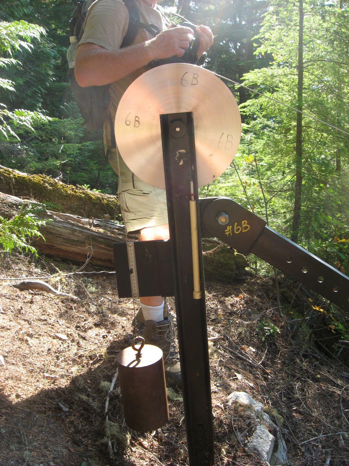
In some areas it is necessary to establish warning systems so that we know if conditions have changed at a known slide area, or if a rapid failure, such as a debris flow, is actually on its way. The Downie Slide is monitored 24-7 with optical devices. A simple mechanical device for monitoring the nearby Checkerboard Slide (which is also above Lake Revelstoke) is shown on Figure 5.3.2. Both of these are very slow-moving rock slides, but it’s very important to be able to detect changes in their rates of motion because at both of these locations a rapid failure would result in large bodies of rock plunging into the reservoir, sending a wall of water over the Revelstoke Dam, potentially destroying the nearby town of Revelstoke.
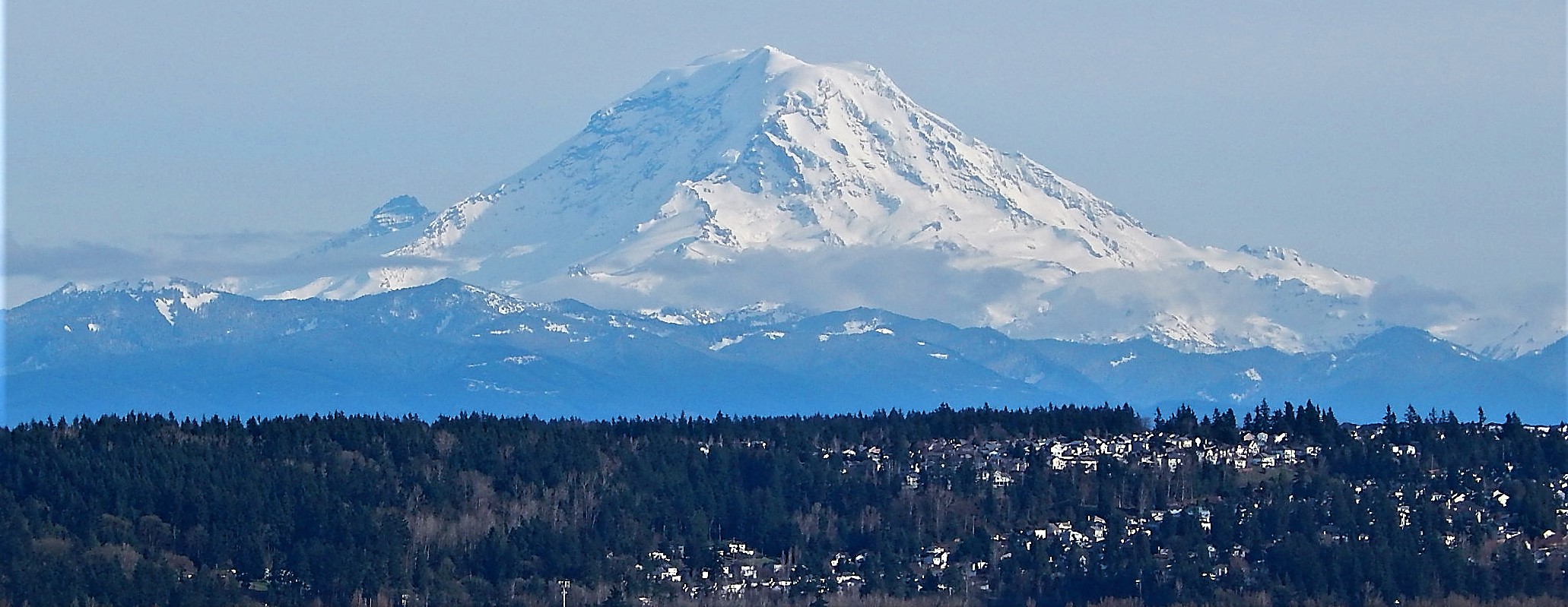
Mt. Rainier in Washington State has the potential to produce massive mud flows or debris flows (technically lahars) with or without a volcanic eruption, and over 100,000 people in the Tacoma, Puyallup and Sumner areas are in harm’s way because they currently reside on deposits from past lahars (Figure 5.3.3). In 1998 a network of acoustic monitors was established around Mt. Rainier. The monitors are embedded in the ground adjacent to expected lahar paths. They provide warnings to emergency officials, and when a lahar is detected the residents of the area will have anywhere from 40 minutes to 3 hours to get to safe ground.[1] There’s more on the risk of lahars at Mt. Rainier in Chapter 7.
It is critical to monitor the weather conditions and stream flows in order to assess changes to the risk of slope failure. Changing weather conditions can be failure triggers, especially in the following ways:
- extreme rain events saturate and weaken surficial materials (and even bedrock),
- extreme rain events lead to stream flooding and so to eroded banks, contributing to failures,
- sudden warming events can trigger rapid snow melt, increasing the amount of water in surface materials and streams, and
- persistent drought will dry out sandy materials making them more prone to failure.
Mitigating the Impacts of Mass Wasting
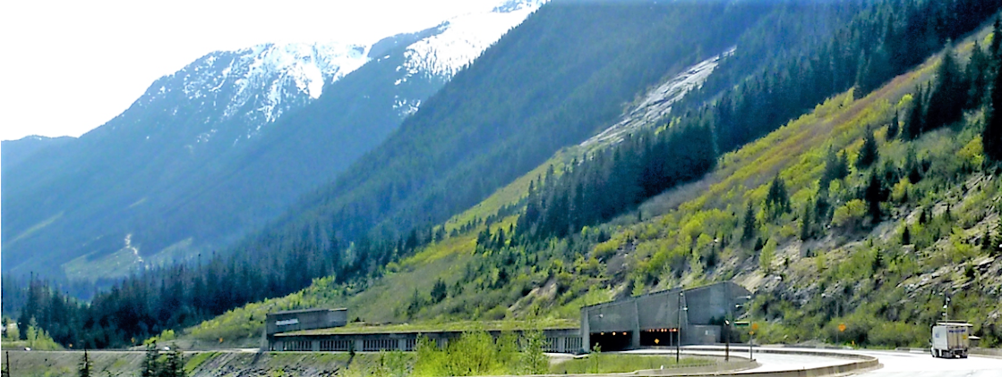
In situations where we can’t predict, prevent, or delay mass-wasting hazards, there are some effective measures that can be taken to minimize the associated risk. For example, many highways in temperate mountainous regions have avalanche shelters like that shown on Figure 5.3.4. In some parts of the world similar features have been built to shelter infrastructure from other types of mass wasting.
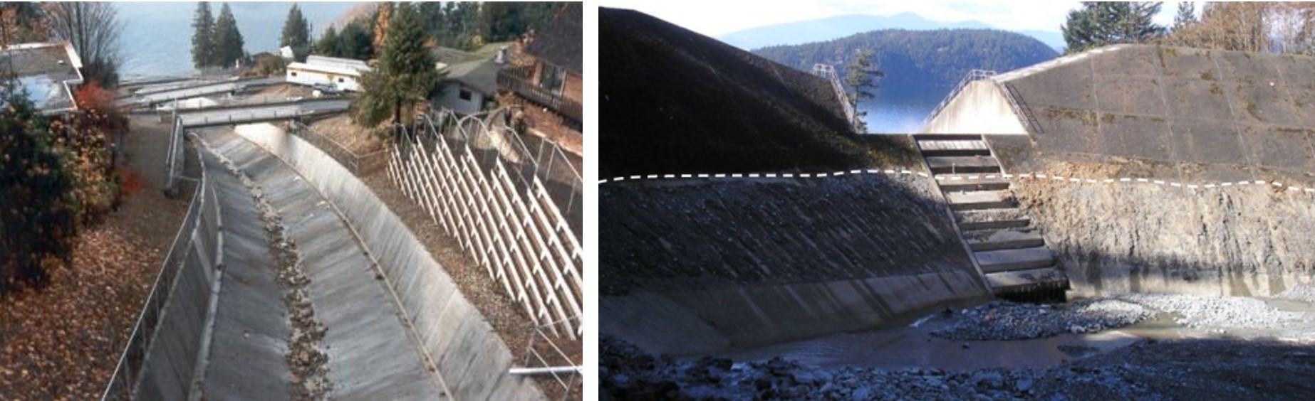
Debris flows are inevitable, unpreventable and unpredictable in many parts of British Columbia (and elsewhere of course), but nowhere more so than along the Sea-to-Sky Highway between Vancouver and Squamish. The results have been deadly and expensive many times in the past. It’s too late now to close this region to the public, so provincial authorities have taken steps to protect residents and traffic on the highway and railway. Debris-flow defensive structures have been constructed on several drainage basins, as shown on Figure 5.3.5. One strategy is to allow the debris to flow quickly through to the ocean along a smooth channel. Another is to capture the debris within a constructed basin that allows water to continue through.
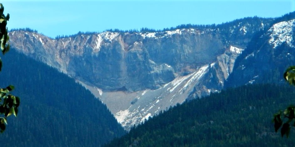
Finally, in situations where we can’t do anything to delay, predict, contain or mitigate slope failures, we simply have to have the common sense to stay away. There is a famous example of this in British Columbia at a site known as Garibaldi, 25 km south of Whistler. In the early 1980s the village of Garibaldi had a population of about 100, with construction underway on some new homes, and plans for many more. In the months that followed the deadly 1980 eruption of Mt. St. Helens the Ministry of Transportation commissioned a geological study that revealed that a steep cliff known as The Barrier (Figure 5.3.6) had collapsed in 1855, leading to a large rock avalanche,[2] and that it was likely to collapse again unpredictably, putting Garibaldi at extreme risk. In an ensuing court case, it was ruled that Garibaldi was not a safe place for people to live. Those that already had homes were compensated, and everyone was ordered to leave.
Media Attributions
- Figure 5.3.1 Steven Earle, CC BY 4.0
- Figure 5.3.2 Photo by Steven Earle, CC BY 4.0
- Figure 5.3.3 Mount Ranier from Centennial Viewpoint by Ron Clausen, 2017, CC BY SA 4.0, via Wikimedia Commons, https://commons.wikimedia.org/wiki/File:Mount_Rainier_from_Centennial_Viewpoint_Park_Auburn_Washington.jpg
- Figure 5.3.4 Photo by Steven Earle, CC BY 4.0
- Figure 5.3.5 Photos by Steven Earle, CC BY 4.0
- Figure 5.3.6 Photo by Steven Earle, CC BY 4.0
- Monitoring Lahars at Mt. Ranier, US Geological Survey, https://www.usgs.gov/volcanoes/mount-rainier/monitoring-lahars-mount-rainier ↵
- Moore, D. P. (1976). The Rubble Creek landslide Garibaldi, British Columbia (Thesis, University of British Columbia). https://open.library.ubc.ca/collections/ubctheses/831/items/1.0052710 ↵