4.3 Glacial Erosion
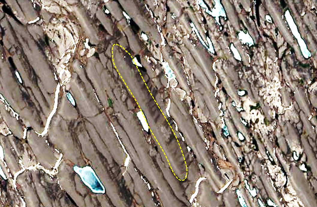
Some of the results of glacial erosion are different in areas with continental glaciation versus alpine glaciation. Continental glaciation tends to produce relatively flat bedrock surfaces, especially where the rock beneath is uniform in strength and there hasn’t been tectonic activity for hundreds of millions of years. In areas with recent tectonic activity and where there are differences between the strength of rocks a glacier will obviously tend to erode the softer and weaker rock more effectively than the harder and stronger rock. Much of central and eastern Canada, which was completely covered by the huge Laurentide Ice Sheet at various times during the Pleistocene, has been eroded to a relatively flat surface. In contrast, the Cordilleran Ice Sheet eroded and accentuated deep valleys and plateaus in the mountainous regions of western Canada and northwestern United States. In many cases the existing relief is also due the presence of glacial deposits—such as drumlins, eskers and moraines (all discussed below)—rather than to differential erosion (Figure 4.3.1).
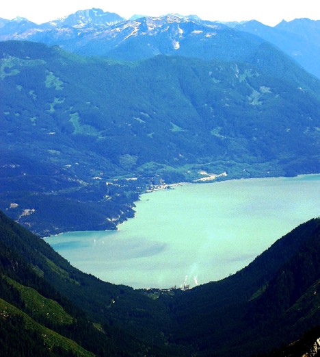
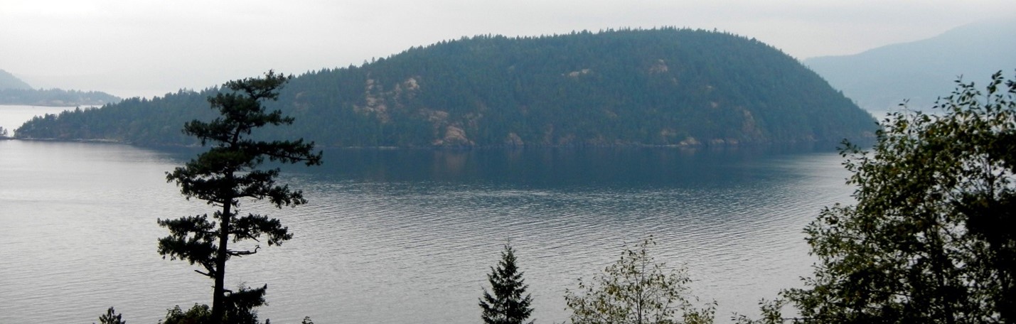
Alpine glaciers produce very different topography than continental glaciers, and much of the topographic variability of mountains in temperate regions can be attributed to glacial erosion. In general, glaciers are much wider than rivers of similar length, and since they tend to erode more at their bases than their sides, they produce wide valleys with relatively flat bottoms and steep sides—known as U-shaped valleys. Howe Sound, north of Vancouver, was occupied by a large glacier that originated in the Squamish, Whistler and Pemberton areas, and then joined the much larger glacier in the Strait of Georgia. Howe Sound and most of its tributary valleys have a pronounced U-shaped profiles (Figure 4.3.2).
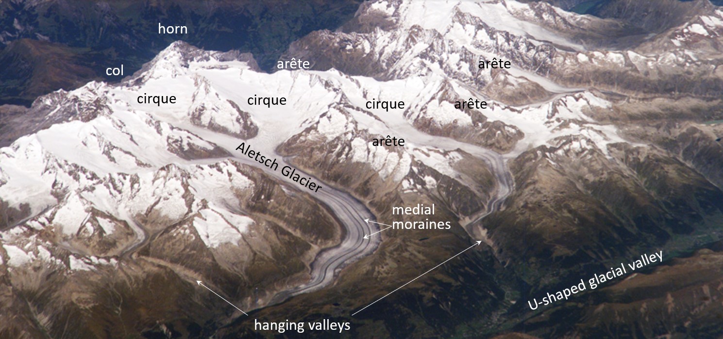
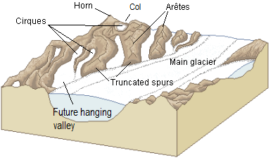
Some of the important features visible on Figure 4.3.3 are arêtes: sharp ridges between U-shaped glacial valleys, cols: low points along arêtes that constitute passes between glacial valleys, horns: steep peaks that have been glacially and freeze-thaw eroded on three or more sides, cirques: bowl-shaped basins that form at the head of a glacial valley, hanging valleys: U-shaped valleys of tributary glaciers that hang above the main valley because the larger main-valley glacier eroded more deeply into the terrain, and truncated spurs: the ends of arêtes (a.k.a. “spurs”) that have been eroded into steep triangle-shaped cliffs by the glacier in the corresponding main valley.
Some of these alpine-glaciation erosional features are also shown on Figure 4.3.4 in diagram form.
Exercise 4.3 Identify Glacial Erosion Features
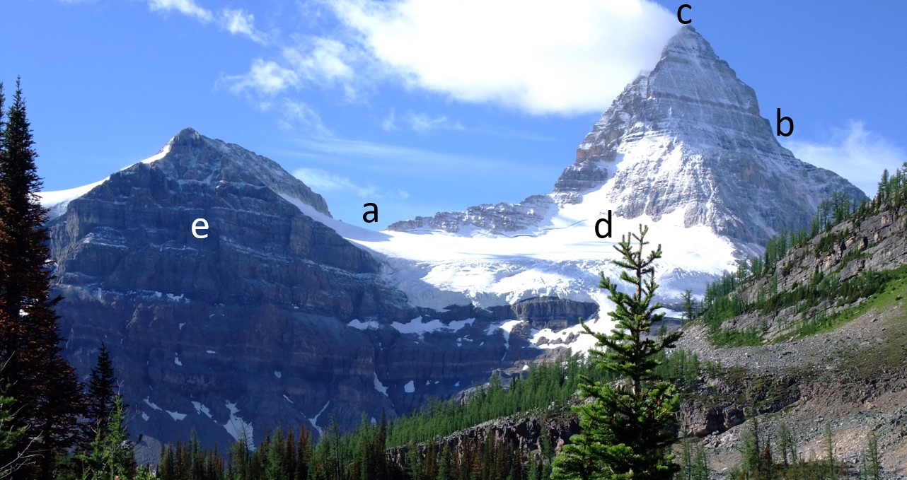
Figure 4.3.5 shows Mt. Assiniboine in the BC Rockies . What are the features at locations a through e? Look for one of each of the following: a horn, an arête, a truncated spur, a cirque and a col. Try to identify some of the numerous other arêtes in this view, as well as another horn.
Exercise answers are provided Appendix 2
A number of other glacial erosion features exist at smaller scales. For example, a drumlin is an elongated feature that is streamlined at the down-ice end (Figure 4.3.6). The one shown is larger than most others, and is almost entirely made up of rock. Drumlins comprised of glacial sediments are very common in some areas of continental glaciation (Figure 4.3.1).
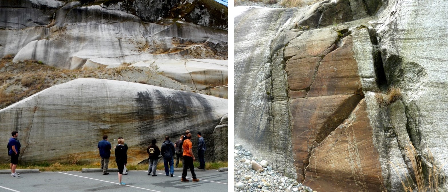
A roche moutonée is another type of elongated erosional feature that has a steep and sometimes jagged down-ice end (Figure 4.3.7 left). On a smaller scale still, glacial grooves (10s of cm to m wide) and glacial striae (mm to cm wide) are created by fragments of rock embedded in the ice at the base of a glacier (Figure 4.3.7 left and right). Glacial striae are very common on rock surfaces eroded by both alpine and continental glaciers.
Lakes are typical features of glacial environments. A lake that is confined to a glacial cirque is known as a tarn (Figure 4.3.8). Tarns are common in areas of alpine glaciation because the ice that forms a cirque typically carves out a depression that then fills with water.

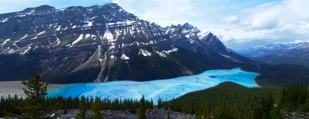
A lake that occupies a glacial valley, but is not confined to a cirque, is known as a finger lake. In some cases a finger lake is confined by a dam formed by an end moraine, in which case it may be called a moraine lake (or moraine-dammed lake) (Figure 4.3.9).
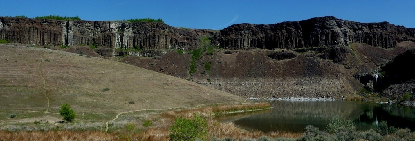
In areas of continental glaciation the crust is depressed by the weight of glacial ice that is up to 4000 m thick. Basins are formed along the edges of continental glaciers (except for those that cover entire continents like Antarctica and Greenland and terminate in the ocean), and these basins fill with glacial melt water. Many such lakes, some of them huge, existed at various times along the southern edge of the Laurentide Ice Sheet. One example is Glacial Lake Missoula, which formed within Idaho and Montana, just south of the BC border. During the latter part of the last glaciation (30 to 15 ka) the ice holding back Lake Missoula retreated enough to allow some of the lake water to start flowing out and this then escalated into a massive and rapid outflow (over days to weeks) during which time much of the volume of the lake drained along the valley of the Columbia River to the Pacific Ocean. It is estimated that this type of flooding happened at least 25 times over that period, and in many cases the rate of outflow was equivalent to the discharge of all of the Earth’s current rivers combined. The record of these massive floods is preserved in the Channelled Scablands of Washington and Oregon (Figure 4.3.10).
- Figure 4.3.1 Public domain NASA image, Photo ID: 85506
- Figure 4.3.2 Photo by keefmon@hotmail.com, 2005, CC BY SA 2.5, via Wikimedia Commons
- Figure 4.3.3 Modified by Steven Earle, CC BY 4.0, from a public domain NASA image, Photo ID: 7195
- Figure 4.3.4 Modified by Steven Earle, CC BY 4.0, from a glacial landscape drawing by Luis Maria Benitez, 2005, Public Domain, via Wikimedia Commons.
- Figure 4.3.5 Modified by Steven Earle, CC BY 4.0, from a photo by Kurt Stegmüller, 2008, CC BY 3.0, via Wikimedia Commons
- Figure 4.3.6 Photo by Steven Earle, CC BY 4.0
- Figure 4.3.7 Photos by Steven Earle, CC BY 4.0
- Figure 4.3.8 Photo by Jeffrey Pang from Madison, NJ, USA, 2007, CC BY 2.0, via Wikimedia Commons
- Figure 4.3.9 Photo by chensiyuan, 2006, CC BY SA 4.0, via Wikimedia Commons
- Figure 4.3.10 Photo by Steven Earle, CC BY 4.0