8.2 Mining and Ore Processing
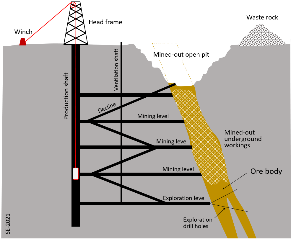
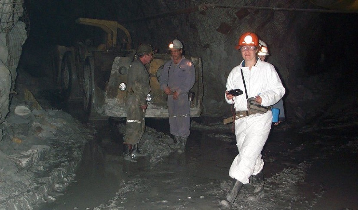
Metal deposits are mined in a variety of different ways depending on their depth, shape, size and grade. Relatively large deposits that are quite close to surface and somewhat regular in shape are mined using open-pit mine methods (Figure 8.1.5 in Section 8.1). Creating a giant hole in the ground is generally cheaper than making an underground mine, but it is also less precise, so it is necessary to mine a lot of waste rock along with the ore, and that waste rock becomes an environmental liability. Relatively deep deposits, or those with elongated or irregular shapes are typically mined from underground with deep vertical shafts, declines (sloped tunnels) and levels (horizontal tunnels) (Figures 8.2.1 and 8.2.2). In this way it is possible to focus the mining on the orebody itself. In some cases, the near-surface part of an orebody is mined with an open pit, while the deeper parts are mined underground.
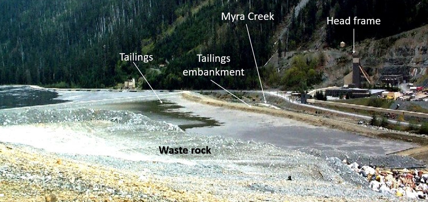
The tailings pond at the Volcanogenic Massive Sulphide copper-zinc-silver-gold Myra Falls Mine on Vancouver Island is shown on Figure 8.2.3. The tailings are contained by an embankment. Also visible in the foreground of Figure 8.2.3 is a pile of waste rock, which is non-ore rock that was mined in order to access the ore. Although this waste rock has low levels of ore minerals, at many mines it contains up to a few percent pyrite. The tailings and the waste rock at most mines are an environmental liability because they both contain pyrite plus small amounts of ore minerals. When pyrite is exposed to oxygen and water it generates sulphuric acid—also known as acid rock drainage (ARD). Acidity itself is a problem to the environment, but because the ore elements, for example copper or lead, are more soluble in acidic water than in neutral water the ARD is also typically quite rich in metals, many of which are toxic. The causes and consequences of ARD are summarized below in Box 8.1.
| Activity | Potential Environmental Risks |
| Mining | Loss of natural environment, wind-blown contaminated dust from open excavations, acid rock drainage (ARD) |
| Waste rock storage | Loss of natural environment, slope failure, wind-blown contaminated dust, ARD |
| Tailings storage | Loss of natural environment, potential slope failure, potential slurry spills, potential leakage of contaminated water, wind-blown contaminated dust, ARD |
| Smelting | Loss of natural environment, toxic particulates and gases from chimneys, leaching of metals from smelter waste material (slag), release of greenhouse gases |
Box 8.1 Acid Rock Drainage at Mt Washington, BC
Any material that contains the mineral pyrite (FeS2), or some other iron sulphide mineral, has the potential to produce acidity in the surrounding surface environment. That’s because pyrite oxidizes quite readily at surface, and its oxidation leads to the release of hydrogen ions (H+) into the surface water and groundwater. A simplified equation for this process is as follows:
2FeS2 + 7O2 + 2H2O -> 2Fe2+ + 4SO42- + 4 H+
pyrite + oxygen + water -> dissolved iron + sulphate + hydrogen ions
Materials around a mine site that might contain pyrite include rock outcrops exposed by mining, road-building or construction, waste rock or any rock that was mined but doesn’t have enough metal to be considered ore, and tailings from a processing plant. The important point is that these materials may have been underground and so not susceptible to weathering, but, because of construction and mining activities they are now exposed to water and oxygen at surface.
Figure 8.2.5 shows part of the Mt. Washington porphyry copper mine on Vancouver Island.[3] Waste rock piles are present in the background, and rock that has been exposed by mining is visible in the foreground. Both are producing acid rock drainage, and the pH of the water in this area is as low as 4.
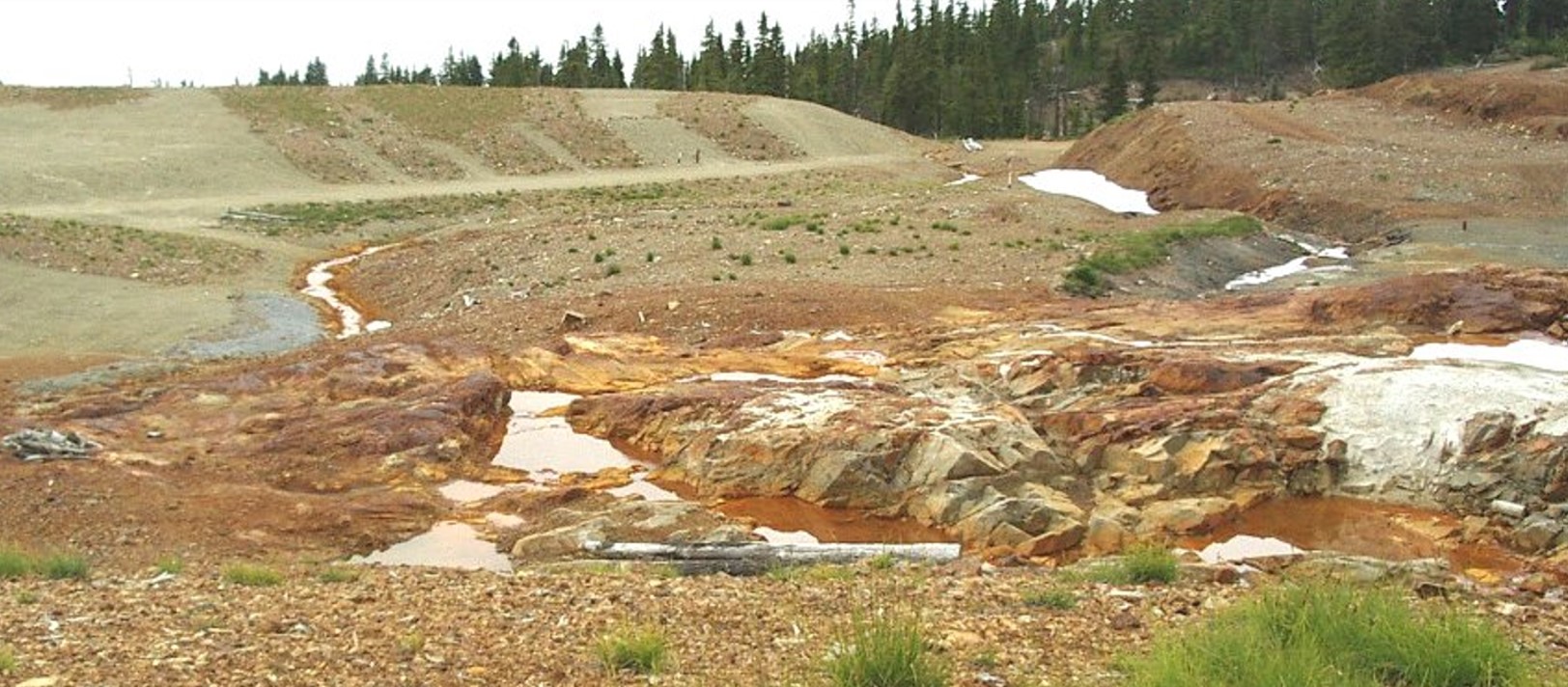
Acid water alone has a negative effect on aquatic and terrestrial organisms, but in most cases the acid drainage from a mine also includes elevated levels of metals. This is because the rocks that are weathering tend to be metal-rich, and also because most metals are more soluble in acidic water than in neutral water.
Water draining from the Mt. Washington Mine flows into the Tsolum River an important salmon stream in the Comox Valley. In the 1930s and 1940s this stream had runs of up to 200,000 pink salmon, 15,000 coho, 11,000 chum and 3,500 steelhead.[4] The mine operated for only 3 years from 1964 to 1966, but by 1987 only 14 coho could be found in the river and other fish stocks were also significantly depleted. In 1982 a fish hatchery released 2.5 million pink salmon fry into the Tsolum River; none returned.
Very low copper concentrations, in the order of 10 µg/L, can be toxic to Pacific salmon.[5] In the 1980s and 1990s copper concentrations in the Tsolum River ranged from 20 to 400 µg/L, while copper concentrations in one of the tributaries leading from the Mt. Washington Mine were in the range 5,000 to 15,000 µg/L.[6]
A remediation plan for the Tsolum River was established in 2003. The plan included steps to reduce the level of acid drainage at source, and also to naturally treat some of the water flowing into the river. The main stream draining the mine site was diverted into an existing wetland, and the flow out of this wetland was controlled so that most flow coincided with peak discharge periods of the Tsolum River (to achieve dilution). Reduction in ARD at source was achieved by diverting some surface drainage around the old mine workings and covering a large part of the workings with a bituminous liner.[7]
By 2010 the copper level in the Tsolum River was consistently below 11 µg/L, and it has continued to drop since then. In 2018 over 220,00 Pink salmon, 32,000 Chum, 4,100 Coho and 600 Steelhead were counted in the river.[8]
Media Attributions
- Figure 8.2.1 Steven Earle, CC BY 4.0
- Figure 8.2.2 Photo by Steven Earle, CC BY 4.0
- Figure 8.2.3 Photo by Steven Earle, CC BY 4.0
- Figure 8.2.4 Steven Earle, CC BY 4.0, after Jesse Allen, 2014, based on public domain Landsat data from the U.S. Geological Survey, via Wikipedia, https://en.wikipedia.org/wiki/Mount_Polley_mine#/media/File:Mount_Polley_Mine_site.jpg; and https://en.wikipedia.org/wiki/Mount_Polley_mine#/media/File:Mount_Polley_Mine_dam_breach_2014.jpg
- Figure 8.2.5 Photo by Steven Earle, CC BY 4.0
- Epps, D. (2016). Quesnel Lake water quality for samples collected August 2014 to August 2016 compared to drinking water and aquatic life guidelines (Memorandum). BC Ministry of Environment. https://www2.gov.bc.ca/assets/gov/environment/air-land-water/spills-and-environmental-emergencies/docs/mt-polley/sample-monitor/2016-12-08_final_ql_memo.pdf ↵
- Wikipedia article on the Sudbury superstack built in 1970: Wikipedia contributors. (2021, September 11). Inco Superstack. Wikipedia, https://en.wikipedia.org/w/index.php?title=Inco_Superstack&oldid=1043763134 ↵
- White, W. & Healey, P. (2007). Mt. Washington Mine remediation project. Tsolum River Restoration Society & SRK Consulting (Canada) Inc. https://dx.doi.org/10.14288/1.0042513 ↵
- (White & Healey, 2007). ↵
- BC Ministry of Environment and Climate Change Strategy (2019). Copper Water Quality Guideline for the Protection of Freshwater Aquatic Life-Technical Report. Water Quality Guideline Series, WQG-03-1. Prov. B.C., Victoria, BC. https://www2.gov.bc.ca/assets/gov/environment/air-land-water/water/waterquality/water-quality-guidelines/approved-wqgs/copper/bc_copper_wqg_aquatic_life_users_guide.pdf ↵
- Regnier, R. (1999). Trend analysis of copper in the Tsolum River at Farnham, the Tsolum River 500 m downstream of Murex Creek, Murex Creek at Duncan Main and Pyrrohotite Creek (report for the BC Ministry of Environment and Climate Change Strategy). https://www2.gov.bc.ca/assets/gov/environment/air-land-water/water/waterquality/monitoring-water-quality/trend_analyses_of_copper_in_the_tsolum_river.pdf ↵
- (White and Healey, 2007) ↵
- Comox Valley Record. (2018, August 9). Tsolum River summer levels continue to drop with rising temperatures (online article). https://www.comoxvalleyrecord.com/news/tsolum-river-summer-levels-continue-to-drop-with-rising-temperatures/ ↵