5.2 Classification of Mass Wasting
- The type of material that failed (typically either bedrock or unconsolidated sediment),
- The mechanism of the failure (how the material moved), and
- The rate at which it moved.
| Failure type | Type of material | Type of motion | Rate of motion |
| Rock fall | Rock fragments | Vertical or near-vertical fall (plus bouncing in many cases) | Very fast (>10s m/s) |
| Rock slide | A large rock body | Motion as a unit along a planar surface (translational sliding) | Typically very slow (mm/y to cm/y), but some can be faster |
| Rock avalanche | A rock body that slides and then breaks into small fragments | Flow At high speeds the mass of rock fragments is suspended on a cushion of air. | Very fast (>10s m/s) |
| Creep or solifluction | Soil or other overburden, in some cases mixed with ice | Flow (although sliding motion may also occur) | Very slow (mm/y to cm/y) |
| Slump | Thick deposits (m to 10s of m) of unconsolidated sediment | Motion as a unit along a curved surface (rotational sliding) | Slow (cm/y to m/y) |
| Mud flow | Loose sediment with a significant component of silt and clay | Flow (a mixture of sediment and water moves down a channel) | Moderate to fast (cm/s to m/s) |
| Debris flow | Sand, gravel and larger fragments | Flow (similar to a mud flow, but typically faster) | Fast (m/s) |
Rock fall
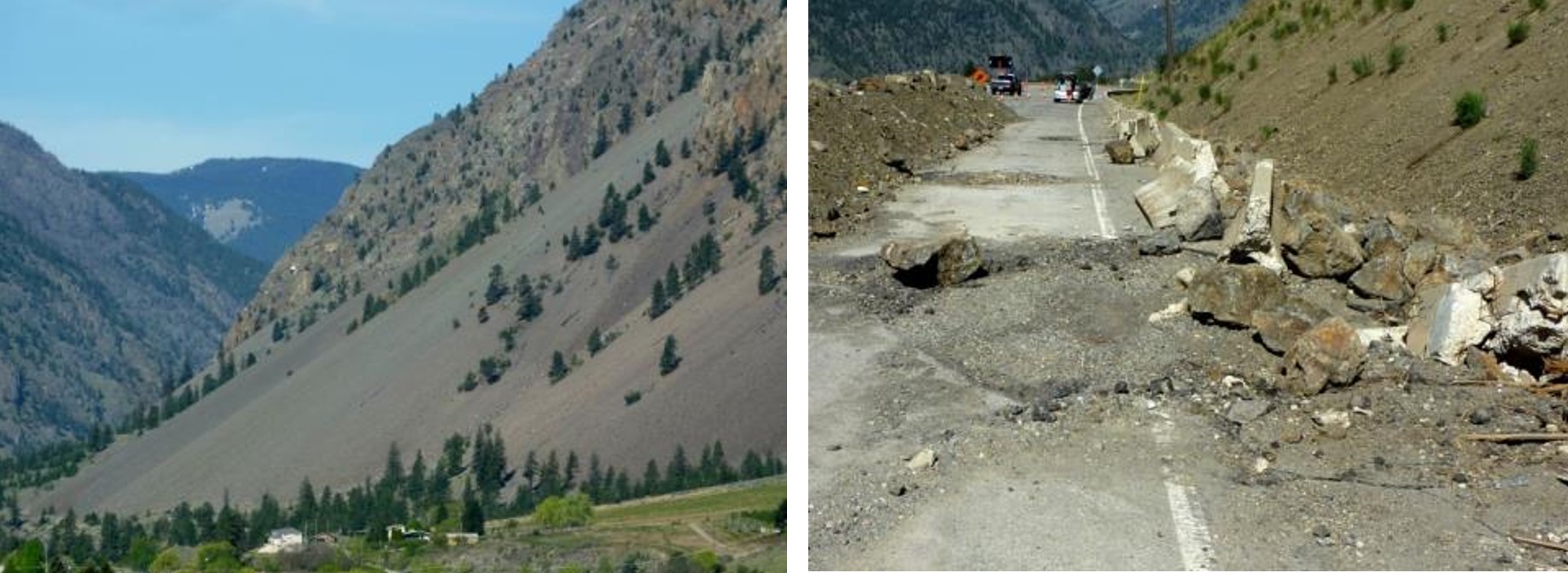
A typical talus slope, near to Keremeos in southern BC, is shown on Figure 5.2.1. In December 2014 a large block of rock split away from a cliff in this same area. It broke into smaller pieces, which fell and tumbled down the slope and crashed into the road, smashing the concrete barriers and gouging out large parts of the pavement.
Rock Slide
A rock slide is the sliding motion of rock along a sloping surface. In most cases the movement is parallel to a fracture, bedding plane or metamorphic foliation plane, and it can range from very slow to moderately fast. The word sackung describes the very slow motion of a block of rock (mm/y to cm/y) on a steep slope. A good example is the Downie Slide north of Revelstoke BC, which is illustrated on Figure 5.2.2. In this case a massive body of rock is very slowly sliding down a steep slope along a plane of weakness that is parallel to the slope.[1] The Downie Slide, which was recognized prior to the construction of the Revelstoke Dam, was moving very slowly at the time (a few cm/year). Geological engineers were concerned that the presence of water in the reservoir (visible on Figure 5.2.2) could further weaken the plane of failure, leading to an acceleration of the motion. The result could have been a catastrophic failure into the reservoir that sent a wall of water over the dam and into the community of Revelstoke. During the construction of the dam, they tunneled into the rock at the base of the slide and drilled hundreds of drainage holes upward into the plane of failure. This allowed water to drain out so that the pressure was reduced, and that stabilized the slide block. BC Hydro monitors this site continuously; the slide block is currently moving slower than it was prior to the construction of the dam.

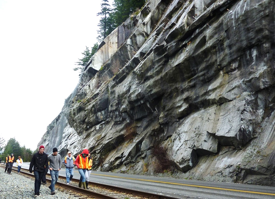
In the summer of 2008, a large block of rock slid rapidly from a steep slope above Highway 99 near to Porteau Cove (40 km north of Vancouver). The block slammed into the highway and the adjacent railway and broke into many pieces. The highway was closed for several days, and the slope was subsequently stabilized with rock bolts and drainage holes. As shown on Figure 5.2.3, the bedrock at this location is fractured parallel to the slope, and this almost certainly contributed to the failure. It is not actually known what trigged this event as the weather was dry and warm during the preceding weeks and there was no significant earthquake in the region.
Rock Avalanche
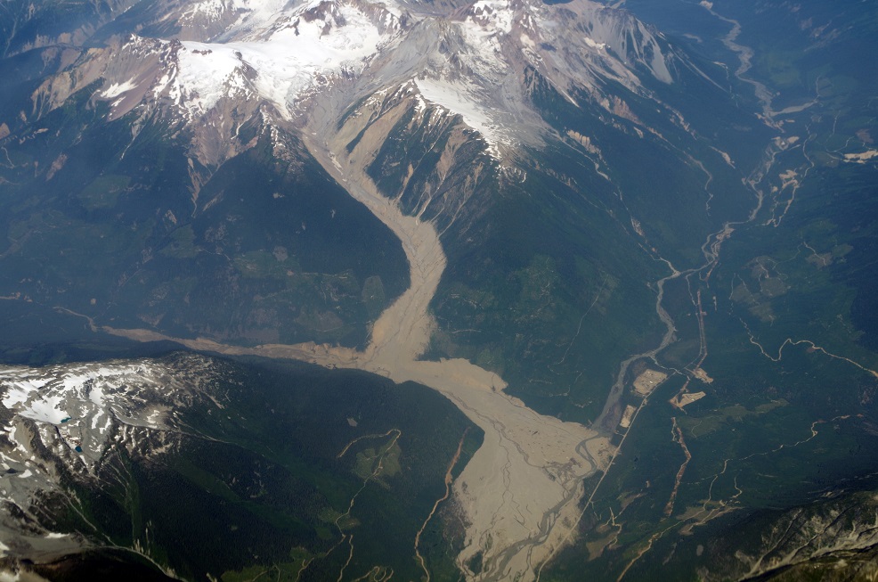
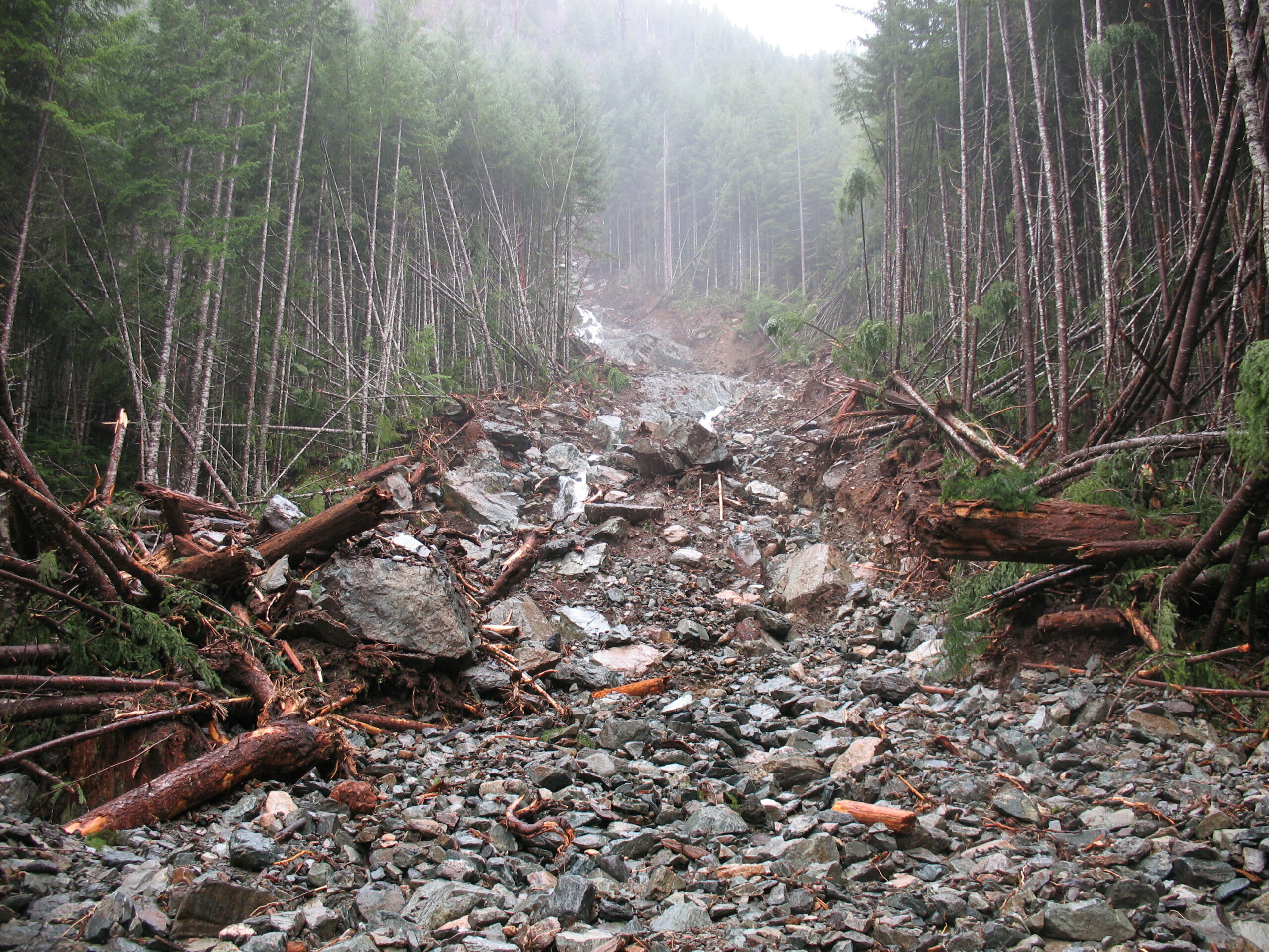
If a rock slide starts moving quickly (m/s) the rock is likely to break into many small pieces, and at that point it can become a rock avalanche, in which the large and small fragments of rock move in a fluid manner supported by cushion of air within and beneath the moving mass. The 1965 Hope Slide (Figure 5.0.1) was a rock avalanche, as was the famous 1903 Frank Slide in southwestern Alberta. The 2010 slide at Mt Meager (west of Lillooet), also a rock avalanche (Figure 5.2.4).[2]
Creep

Slump
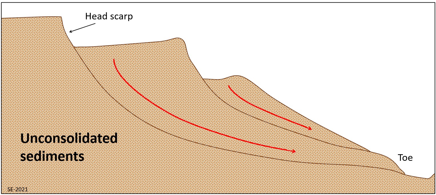
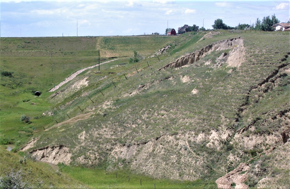
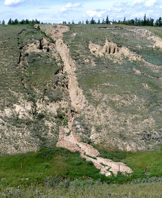
Slump is a type of slide (movement as a mass), that takes place within thick unconsolidated deposits (typically greater than 10 m). Slumps involve movement along a curved surface, with downward motion near to the top and outward motion towards the bottom (Figure 5.2.7). They are typically caused by an excess of water within the materials on a steep slope.
An example of a slump in the Lethbridge area, Alberta, is shown on Figure 5.2.8. This feature has likely been active for many decades, and moves a little more whenever there are heavy spring rains and significant snow-melt runoff. The toe of the slump is failing because it has been eroded by the small stream at the bottom.
Mud Flows and Debris Flows
Exercise 5.2 Classifying Slope Failures
The four photos below show some of the different types of slope failures described above. Try to identify the different types, and in each case provide some criteria for why you made that choice.
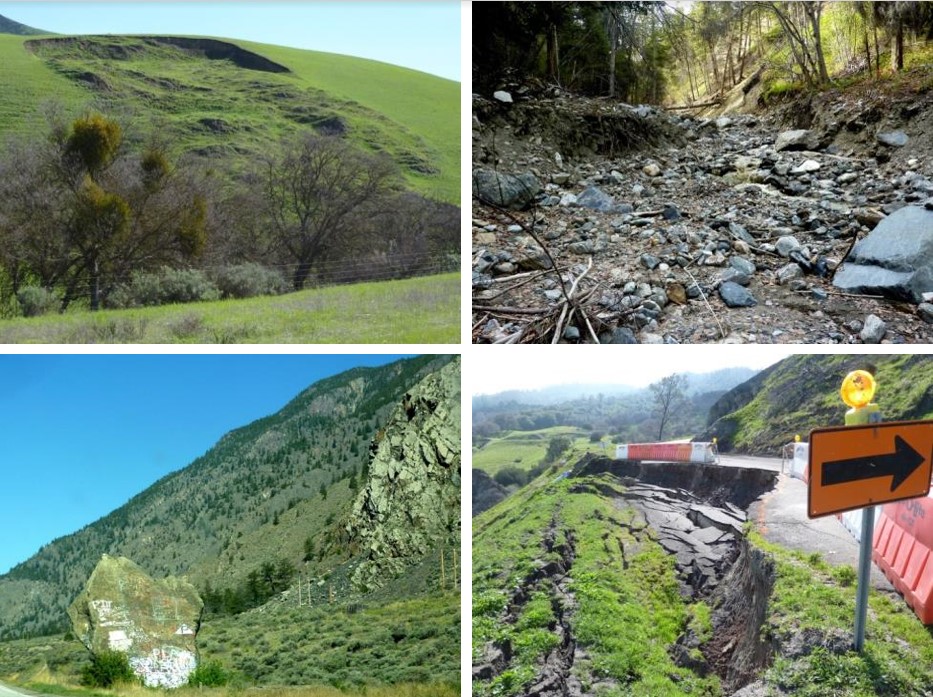
Exercise answers are provided Appendix 2
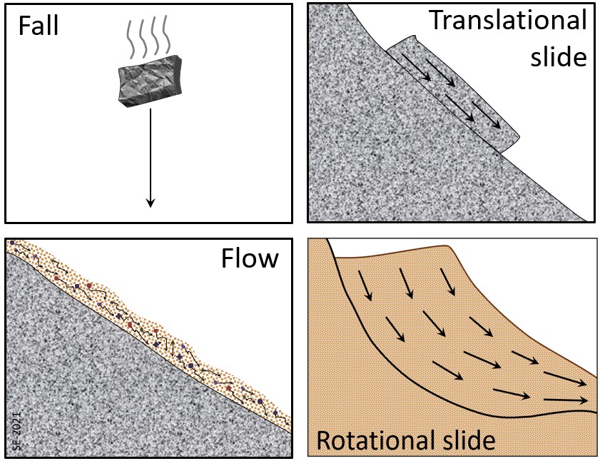
As already noted, to understand a slope failure we need to be able to determine what type of material moved, what type (or types) of motion were involved, and how quickly it moved. The type of motion is the most important of these, and so Figure 5.2.11 is provided here to help you clearly understand how things moved in different types of slope failure.
Exercise 5.3 Slope Failure Field Trip
- What has failed (is it loose sediments or solid rock)?
- How has it failed (slide or flow)?
- How quickly did the material move?
- How long ago did it happen (or is it still happening)?
- What is the risk for future failure at this location?
Box 5.1 The November 2020 Mass Wasting Events at Elliot Creek, BC
A summary of the various different phases of this mass wasting event is provided on the graphic below.

Media Attributions
- Figure 5.2.1 Photos by Steven Earle, CC BY 4.0
- Figure 5.2.2 Image from Google Earth.
- Figure 5.2.3 Photo by Steven Earle, CC BY 4.0
- Figure 5.2.4 2010 Mount Meager Landslide by Tim Gage, 2014, CC BY SA 2.0, via Wikimedia Commons, https://commons.wikimedia.org/wiki/File:2010_Mount_Meager_landslide.jpg
- Figure 5.2.5 Photo by Steven Earle, CC BY 4.0
- Figure 5.2.6 Steven Earle, CC BY 4.0
- Figure 5.2.7 Photo by Steven Earle, CC BY 4.0
- Figure 5.2.8 Photo by Steven Earle, CC BY 4.0
- Figure 5.2.9 Photo by Steven Earle, CC BY 4.0
- Figure 5.2.10 Photo by Steven Earle, CC BY 4.0
- Figure 5.2.11 Steven Earle, CC BY 4.0
- Figure 5.2.12 Steven Earle, CC BY 4.0. All of the photographs are public domain and have been provided by 49North Helicopters, https://49northhelicopters.com; satellite imagery is from Google Earth.
- Kalenchuk, K. S., Hutchinson, D. J., Diederichs, M. S., and Moore, D. (2012). Downie Slide, British Columbia, Canada. In Clague, J. J. & D. Stead (Eds.), Landslides: Types, Mechanisms and Modeling (p. 345-358). Cambridge University Press. ↵
- Guthrie, R. et al., (2012). The 6 August 2010 Mount Meager rock slide-debris flow, Coast Mountains, British Columbia: characteristics, dynamics, and implications for hazard and risk assessment. Natural Hazards Earth System Science, 12(5), 1277–1294, https://doi.org/10.5194/nhess-12-1277-2012. ↵
- Stewart, B. (2021, June 23). Scientists, Homalco First Nation team up to probe massive B.C. landslide — and its impact on salmon. CBC News. https://www.cbc.ca/news/canada/british-columbia/bc-landslide-science-tsunami-earthquake-1.6075933 ↵